- News
- Dense fog, cold wave to grip Punjab and Haryana for two more days
Dense fog, cold wave to grip Punjab and Haryana for two more days
Dense fog and cold wave conditions will persist in Punjab, Haryana, and Himachal Pradesh for two more days with visibility as low as 50 meters in some areas. A fresh western disturbance is expected to bring light to moderate rainfall and snowfall in the northwest regions of India from January 10 to 12.
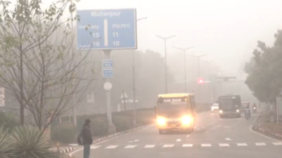
Dense fog with visibility of less than 50 meters was reported in some parts of Punjab, and visibility of up to 200 meters was noted in Haryana and Himachal Pradesh. Zero visibility was reported at Amritsar, Patiala, and Adampur, with 20 meters in Ludhiana in Punjab, 50 meters in Bilaspur, 100 meters in Mandi in Himachal Pradesh, 80 meters in Chandigarh, and 180 meters in Karnal in Haryana.
According to the India Meteorological Department, a fresh western disturbance and its interaction with easterly winds are likely to affect Northwest India from January 10 to 12.
Under its influence, light to moderate rainfall, scattered to fairly widespread rainfall/snowfall is likely over the Western Himalayan region, and light to moderate isolated to scattered rainfall is expected over the plains of Northwest India during the same period.
Minimum temperatures were reported at 1-3°C over isolated places in Himachal Pradesh and 5-10°C over many parts of the Northwest.
During the past 24 hours, there was a fall in minimum temperatures by 1-5°C in isolated places in Himachal Pradesh and Haryana. The minimum temperatures were reported above normal (1°C to 3°C) at isolated places over Punjab. A fall in minimum temperatures by about 2°C is likely over Northwest India during the next 24 hours, with a gradual rise by 2-4°C thereafter.
Dense to very dense fog conditions are likely to prevail during night/early morning hours in some parts of Punjab, Haryana, and Himachal Pradesh until January 10.
End of Article
FOLLOW US ON SOCIAL MEDIA


Photostories

Hot Picks
TOP TRENDING
Popular Categories
Hot on the Web
Top Trends
Champions Trophy 2025Delhi Election 2025PM Keir StarmerRavi ShastriHow did Brain Matusz DieKalea ChevalierSam KonstasWho is Anita AnandJustin TrudeauBJP Candidates for Delhi ElectionElon MuskKarnataka SSLC Exam 2025PM Modi Pariksha Pe CharchaUGC Draft Regulation 2025Kerala Human Skull in FridgeDonald TrumpArshdeep SinghLive Cricket Score
Trending Topics
Living and entertainment
Latest News
'Bigg Boss 18': Shilpa Shirodkar labels Vivian Dsena a 'loser' while clarifying her loyalty to Karan Veer MehraNYT Strands January 08, 2025: Clues, answers, Spangram for todayAuthorities begin excavation at sites following discovery of 'ancient temples' in FirozabadAs cybersecurity threats rise, ISB Executive Education's Cybersecurity for Leaders programme equips leaders with AI-integrated solutions'Hope Modi ji keeps on giving us visa': 100 Pakistani devotees offer 'chadar' at Ajmer Dargah during UrsSa Re Ga Ma Pa contestants Ujwal and Parvathi bag their first song ‘Tere Sang’ Composed by Sachet and ParamparaFPI cautious on Indian market until further clarity on Q3 resultsThis woman is both father and mother to her two sons, know how is it possibleCES 2025: After five-year wait, Sony-Honda's Afeela is finally a reality'Lights, car engines left on': Monster wildfire sparks panicked evacuations in Los AngelesTomarket secret daily combo for January 8: How to unlock combo and moreMeta ends fact-checking, embraces Trump-era free speech agendaSA20 Season 3: Consistent Paarl Royals eye maiden title in 2025Yuki Bhambri shines in Auckland, reaches quarters; Sriram Balaji falls in AdelaideDreame Technology showcases smart home ecosystem at CES 2025Austrian Foreign Minister Alexander Schallenberg to serve as the country's interim leaderAnand Mahindra’s traffic signal picture highlights safety and faith: 'The Gods are always looking over us…'Thaman Teases Fans with an Update on Jason Sanjay's Directorial Debut
Copyright © 2025 Bennett, Coleman & Co. Ltd. All rights reserved. For reprint rights: Times Syndication Service