By Gabrielle Antonioli, Montana State University /BOISE, IDAHO/
Being a snow scientist is an interesting career. Growing up in a small town in Montana, I was immersed in snow. But I saw it as one set thing—a blanket, unmoving, a cold, white mass. Only far later in life did I learn what a changing and integral role snow plays in our day-to-day life. Snow drives the winter economies of most Western states, acts as water reservoirs for those same regions and far beyond and is a fundamental part of life—whether we see it fall on our city streets or not.
I wasn’t always interested in studying snow, though. I received my bachelor’s degree in organismal biology, aimed at a career in medicine. A fundamental switch flipped in my brain as I worked in mountain environments, found snow science and ski mountaineering mentors, and realized that snow could be as changing and complex as any living organism. Mitigating risk and hazard while skiing – alongside trying to understand the evolution of a snowpack in a given mountain range – evolved into an encompassing and engaging mental and physical process for me. It is from this divergence in thought and passion that I found my path to the Earth sciences while skiing, teaching avalanche education, and backcountry ski-guiding. I am now completing a master’s in Earth sciences, focusing on snow science, at Montana State University. Amidst finishing this degree remotely due to the COVID-19 pandemic, I chose to move to Idaho and test my skills in a different environment. I am now working as a research technician for the NASA SnowEx project based in Boise, Idaho.

Credit: G. Antonioli
SnowEx is a multi-year NASA campaign to study snow using remote sensing. This involves things like radar, remote-controlled aircraft (UAVs), light detection and ranging (LiDAR), and more. This research is designed to inform plans for a future NASA satellite that would study snow from space. The primary instrument we’re using this year is Inteferometric Synthetic Aperture Radar (InSAR). InSAR flies over the Boise site each week, as well as other sites located near more distant mountain ranges, and uses radar to estimate the depth of the snow. We compare the measurements over time as InSAR continues its weekly flights over this site. The change in snow depth is directly related to the change in how much water is stored in the snowpack, which scientists call snow water equivalent (SWE). This is particularly important in mountain ranges that supply water to urban areas.
Even the most precise remote sensing instruments need to be validated with actual snow data collected in the field. For this reason, the field teams of technicians set out to various study plots across the Western U.S. each week to dig snow pits, identify the structure of the snowpack, measure density and liquid water content, and track each new snowfall. We travel on snowshoe, ski, or snowmobile. The teams I am on visit sites using backcountry skis with removable sticky skins and a special binding that rotates to either free the heel of a ski boot or lock it in place, designed for both uphill and downhill travel.


Credit: G. Antonioli
For our first field campaign mid-January, our team drove a winding highway to reach a mountain trailhead far outside of Boise known as Banner Summit, the upper reaches of which source water for rivers and groundwater that Boise locals utilize. We loaded our packs with science gear and used skis to reach the Banner Summit research site. In addition to the density scales and SWE measuring devices we bring, each site has stationary equipment in place to measure a bevy of meteorological variables—like new snowfall, SWE, total depth of snow, and wind speed. The depth and SWE measured by these set stations is also compared to the InSAR estimates, in addition to our on-the-ground measurements.

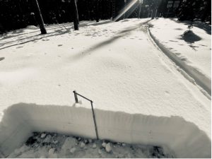
(R): Measuring a later season snowpack stacking up outside of Boise, Idaho in January 2021.
Credit: G. Antonioli
So, why is so much time and effort being devoted to finding a better way to monitor snow cover if we have things like snow telemetry stations (we call them SNOTELs) and stream gauges already in place to monitor snowfall and subsequent runoff? The answer is that there are disparities in weather patterns, rising rain lines (or the elevation at which rain is cold enough to turn to snow) in the mountains, and the ever-changing climate that is at our doorstep. For my master’s thesis, I measured variability in snowfall amounts on different types of terrain and during various storms Hyalite Canyon, Montana. I ski in this canyon often and know that the upper elevation SNOTEL under-reports snowfall amounts by about half—not due to instrumentation error, but due to the location of the station as well as the terrain surrounding it. Not only is this a common problem, but disparities like this make a huge difference for avalanche and hydrologic forecasters alike. I am hopeful that in the future, fusing different technologies like those in use for SnowEx, along with validation from on-the-ground data like my snow pits, will alleviate these issues and help locations that rely on snow melt for water more accurately monitor and plan for the future.

Credit: G. Antonioli
