Fernanda Henderikx-Freitas, assistant professor at University of Hawaii, is the lead principal investigator of the PACE validation team called the Hawaii Ocean Time-series program for validation of the PACE Mission in oligotrophic waters (HOT-PACE). The group is one of many in a campaign set out to gather data around the world to check the accuracy of information from NASA’s PACE (Plankton, Aerosol, Cloud, ocean Ecosystem) satellite up in orbit. She and her team recently took to the seas for the first segment of a three-year campaign to study the phytoplankton in the ocean surrounding Hawaii.
Where did you go for your field campaign and why did you choose that location?
We went to Station ALOHA, which is about 62.1 miles (100 kilometers) north of Oahu. It is a site that has been visited nearly monthly since 1988 as part of a long-term sampling program called the Hawaiian Ocean Time-series (HOT). We piggybacked on one of their monthly cruises, which last 4-7 days. We’re hoping to continue gathering data there for the next three years. Since there’s been oceanographic data collected at Station ALOHA for over 35 years now, we understand a lot of what the ocean properties should look like, which makes it a perfect location for a satellite validation site where data accuracy is so important.
How are you gathering your data?
We are focusing on the very basic information about how light interacts with water, which we need to validate PACE’s data. Whenever we see the clear sky overhead and we know the PACE satellite is close by, we’re going to be out there collecting water. We run seawater through special filters that get immediately frozen at minus 112 Fahrenheit (minus 80 degrees Celsius) for later analysis in the lab back on land where we determinate pigment composition and absorption properties by particles and dissolved materials in the water.
We also have a series of instruments that measure the total absorption and scattering properties of particles in the water at high resolution using a pump system where water is diverted from a depth of about 23 feet (7 meters) into the ship laboratories.
Finally, we have instruments that we throw in the water that look at the light profile in the water column, as well as another instrument that we point at the sky to look at optical properties of the atmospheric path between us and the satellite.
How do the instruments that you use compare to what PACE uses up in orbit?
PACE is a hyperspectral satellite, and on the ship we have hyperspectral sensors that look at both the absorption and scattering properties of seawater. These properties are key for informing satellite models that try to convert the raw reflectance signal that the satellite receives to meaningful quantities that we are interested in. For example, quantities of organic and inorganic carbon concentrations or phytoplankton-specific concentrations. Throughout our first cruise, which lasted five days, we had these instruments on the entire time, so that maximizes the chance of us getting a match up with the satellite.
We also have a hyperspectral radiometer that we use to profile the water column once a day while on the cruise — this radiometer has as many wavelengths as PACE has, and provides the closest type of data to the data measured by the satellite, which makes it incredibly important and useful in validation and calibration efforts.
How are you planning on using PACE data in your own research?
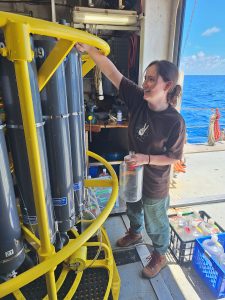
We are very interested in better understanding the relationships between bulk optical properties of the water and phytoplankton community structure, a research area that we think PACE is very well poised to help advance. Paige Dillen is a graduate student on our team who will go on every cruise to collect validation data for PACE and will also base her whole project on PACE. She’ll be looking at the relationships between pigment composition and phytoplankton absorption, which could help develop and improve satellite algorithms in the future.
What do you enjoy about field work?
I love seeing the night sky out here. You just look up and you see the Milky Way and meteor showers because you’re so remote. You can’t get it anywhere else. Seeing all the wonderful microscopic creatures is also amazing — we have a series of microscopes and imaging tools onboard that really help us feel connected with the water we are sampling. There is something very special about being able to collect your own data, it makes you feel like you’re completely involved in your research.
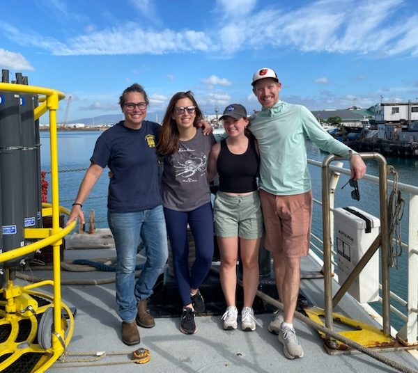
Header image caption: HOT-PACE team on HOT 351, July 2024, onboard the R/V Kilo Moana: From left to right: Angelicque White, Fernanda Henderikx-Freitas, Paige Dillen, Tully Rohrer. “We are so excited to have a role in providing these essential datasets!” said Henderikx-Freitas. Credit: Brandon Brenes.
By Erica McNamee, Science writer at NASA’s Goddard Space Flight Center