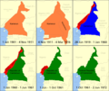
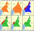
File:Cameroon boundary changes-de.svg
From Wikimedia Commons, the free media repository
Jump to navigation
Jump to search

Size of this PNG preview of this SVG file: 665 × 600 pixels. Other resolutions: 266 × 240 pixels | 532 × 480 pixels | 851 × 768 pixels | 1,135 × 1,024 pixels | 2,270 × 2,048 pixels | 1,002 × 904 pixels.
Original file (SVG file, nominally 1,002 × 904 pixels, file size: 1.05 MB)
File information
Structured data
Captions
Captions
Add a one-line explanation of what this file represents
Summary
[edit]| DescriptionCameroon boundary changes-de.svg |
Deutsch: Änderung des Grenzverlaufs von Kamerun.
English: Boundary changes in Cameroon.
Français : Évolution des frontières du Cameroun entre 1901 et 1962
Italiano: Evoluzione delle frontiere del Camerun tra il 1901 ed il 1962
Deutsch: Die deutsche Kolonie Kamerun
English: German colony of Kamerun
Français : Colonie allemande du Cameroun
Italiano: Camerun tedesco
Deutsch: Cameroons
English: British Cameroons
Français : Cameroun britannique
Italiano: Camerun britannico
Deutsch: Französisch-Kamerun
English: French Cameroun
Français : Cameroun français
Italiano: Camerun francese
Deutsch: Unabhängiges Kamerun
English: Independent Cameroon
Français : Cameroun indépendant
Italiano: Camerun indipendente |
| Date | |
| Source | Own work |
| Author | Augusta 89, German adaption, minor color, layout and font changes: Furfur |
| Permission (Reusing this file) |
I, the copyright holder of this work, hereby publish it under the following license: This file is licensed under the Creative Commons Attribution-Share Alike 4.0 International license.
|
| Other versions |
|
This map was improved or created by the Wikigraphists of the Graphic Lab (fr). You can propose images to clean up, improve, create or translate as well. |
File history
Click on a date/time to view the file as it appeared at that time.
| Date/Time | Thumbnail | Dimensions | User | Comment | |
|---|---|---|---|---|---|
| current | 20:57, 2 December 2023 |  | 1,002 × 904 (1.05 MB) | Furfur (talk | contribs) | Detailfehler |
| 00:02, 15 October 2023 |  | 1,002 × 904 (543 KB) | Furfur (talk | contribs) | =={{int:filedesc}}== {{Information |description={{de|1=Änderung des Grenzverlaufs von Kamerun.}} {{en|1=Boundary changes in Cameroon.}} {{fr|1=Évolution des frontières du Cameroun entre 1901 et 1962}} {{it|1=Evoluzione delle frontiere del Camerun tra il 1901 ed il 1962}} <br> {{legend|#2caaff|{{de|Die deutsche Kolonie Kamerun 30px – Seit 1884 Protektorat, ''Deutsch-Westafrika'' bis 1891, ''Deutsch-Nordwestafrika'' bis 1901, danach in Kame... |
You cannot overwrite this file.
File usage on Commons
The following 3 pages use this file:
File usage on other wikis
The following other wikis use this file:
- Usage on de.wikipedia.org
- Usage on de.wikivoyage.org
- Usage on no.wikipedia.org
Metadata
This file contains additional information such as Exif metadata which may have been added by the digital camera, scanner, or software program used to create or digitize it. If the file has been modified from its original state, some details such as the timestamp may not fully reflect those of the original file. The timestamp is only as accurate as the clock in the camera, and it may be completely wrong.
| Width | 1002.11px |
|---|---|
| Height | 904.008px |


