Show EOL distros:
Package Summary
Geographic mapping using Open Street Map data.
- Author: Jack O'Quin
- License: BSD
- Source: git https://github.com/ros-geographic-info/open_street_map.git (branch: rosbuild)
Package Summary
Geographic mapping using Open Street Map data.
- Author: Jack O'Quin
- License: BSD
- Source: git https://github.com/ros-geographic-info/open_street_map.git (branch: rosbuild)
Package Summary
Geographic mapping using Open Street Map data.
- Maintainer: Jack O'Quin <jack.oquin AT gmail DOT com>
- Author: Jack O'Quin
- License: BSD
- Bug / feature tracker: https://github.com/ros-geographic-info/open_street_map/issues
- Source: git https://github.com/ros-geographic-info/open_street_map.git (branch: master)
Package Summary
Geographic mapping using Open Street Map data.
- Maintainer status: maintained
- Maintainer: Jack O'Quin <jack.oquin AT gmail DOT com>
- Author: Jack O'Quin
- License: BSD
- Bug / feature tracker: https://github.com/ros-geographic-info/open_street_map/issues
- Source: git https://github.com/ros-geographic-info/open_street_map.git (branch: master)
Contents
Overview
This experimental package was an early rapid-prototyping test bed for the geographic_info API for Open Street Map.
It is no longer in active development, but some people have found it useful, and it still has some level of support.
Uniform Resource Locators
The location of XML map data in Open Street Map format is specified by URL. The current implementation only supports these URL types:
file:///full/path/to/local/map.xml
package://ros_package/data/map.osm
ROS Interface
osm_server node
ROS node that parses XML in Open Street Map format and returns geographic_msgs data to the caller.Services
get_geographic_map (geographic_msgs/GetGeographicMap)- OSM map data from the requested URL
viz_osm node
ROS node that requests Open Street Map geographic_msgs information from the osm_server node, publishing it as rviz visualization markers.Published Topics
visualization_marker_array (visualization_msgs/MarkerArray)- Markers for OSM map data from the requested URL.
Services Called
get_geographic_map (geographic_msgs/GetGeographicMap)- OSM map data for the requested URL.
Parameters
map_url (string)- Uniform Resource Locator for XML map in OSM format.
viz_osm Launch File
Runs the osm_cartography nodes, passing the URL of a local file containing the map.
Because UTM map coordinates are generally too large for the float representation used by rviz, it will probably be necessary to publish a transform to some nearby Cartesian coordinate frame within about 10 km, and use that for visualization. You can name that as you like, these examples call it map_local.
Arguments
url (string)
- Uniform Resource Locator for XML map in OSM format.
Example
In one terminal window, create a transform from the /map frame to /local_map:
rosrun tf static_transform_publisher 622150 3362350 0 0 0 0 1 map local_map 100
Then, launch the visualization nodes:
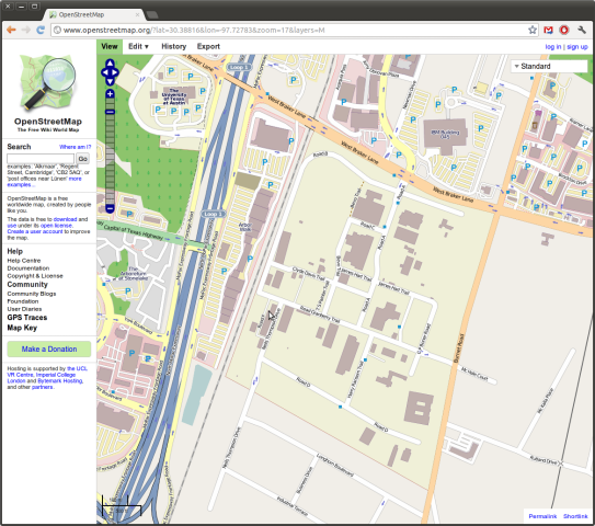
roslaunch osm_cartography viz_osm.launch url:=package://osm_cartography/tests/prc.osm
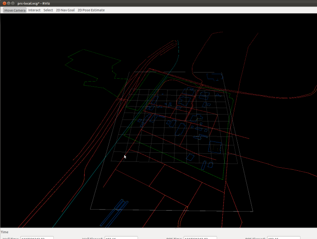
Finally, run rviz, create a Marker display and set the static frame to local_map. You'll probably need to zoom out.
Map Visualization
The goal is to translate OSM data for a region into rviz markers. Currently, the viz_osm node only publishes "interesting" information, like roads and buildings. For a full implementation, that will need to be selectable.


