


Mar-a-Lago among swathes of US predicted to be underwater by 2100... use our map to see if YOUR home's at risk
A new interactive map has revealed dozens of US cities could be underwater by 2100 due to rising sea levels.
An international team of researchers estimated that global sea levels could rise by a staggering 6.2 feet by the year 2100 if carbon dioxide (CO2) emissions continue to increase.
That is roughly double the most recent United Nations global projection, and the researchers said this scenario is 'very likely,' with a 90 percent chance of becoming reality if humanity does not substantially cut emissions.
Researchers discovered that people living on the East Coast would be hit the hardest with large portions of New York City, Boston, Atlantic City and Miami submerged.
The map also predicted that President Donald Trump's Mar-a-Lago resort, located in Palm Beach, Florida will also be underwater in about 75 years.
However, the West Coast was predicted to see less flooding even after scientists have long said that the entire state of California would eventually be underwater.
'Our new very likely projections highlight just how large the uncertainties are when it comes to sea-level rise,' said study lead author Benjamin Grandey, Senior Research Fellow at Nanyang Technological University (NTU), Singapore.
'The high-end projection of [6.2 feet] underscores the need for decision-makers to plan for critical infrastructure accordingly. More importantly, these results emphasize the importance of climate mitigation through reducing greenhouse gas emissions.'
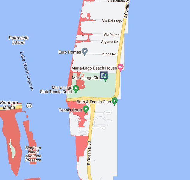
The map also predicted that President Donald Trump's Mar-a-Lago resort, located in Palm Beach, Florida will also be underwater in about 75 years
Climate Central's Coastal Risk Screening Tool released the map, allowing people to see if their home would be impacted by rising sea levels (shown as red).
Climate scientists have kept a watchful eye on the East Coast amid fears of melting glaciers. And the new map shows they may have had good reason.
Significant portions of coastal cities such Philadelphia, Pennsylvania, Charleston, North Carolina, Savannah, Georgia and Miami, Florida would be underwater.
Along the Gulf Coast, Mobile, Alabama, New Orleans, Louisiana and Galveston, Texas would be mostly flood as sea levels rise.
On the West Coast, major parts of Tacoma, Washington as well as the San Francisco Bay Area, Huntington Beach and San Diego, California would succumb to the rising waters.
But interestingly, this side of the country would be far less affected by sea level rise than the southern and eastern coasts of the US.
Scientists think this is because the land along the West Coast is actually rising too due to shifting tectonic plates, which causes sea levels to increase at a slower pace than the national average, according to SeaLevelRise.org.
It's not just cities that are under threat. Some iconic parks, nature areas and wildlife refuges could be plunged into the ocean too.

Climate Central's Coastal Risk Screening Tool shows the areas around the globe that would be worst hit by sea level rise, with submerged areas in red. A 6.2-foot increase would submerge much of New York City

Under this 'very likely' scenario, Boston would be mostly underwater as well
That includes Everglades National park in Florida, Atchafalaya Delta Wildlife Management Area in Louisiana, Blackwater National Wildlife Refuge in Maryland and Grizzly Island Wildlife Area in California.
Current sea level projections rely on a range of methods to model climate processes.
For example, some projections include well-understood phenomena like glacier melting.
But others incorporate more uncertain events, such as abrupt ice shelf collapse.

Miami would also see significant inundation. In the US, people living on the East Coast would be worst hit by sea level rise

Along the Gulf Coast, rising waters would close in on New Orleans
As a result, these models produce varying projections, making it difficult to say with certainty how much sea levels will rise over time.
In its IPCC Sixth Assessment Report, released in 2023, the UN estimated that under high-emission scenarios, global sea levels would rise by between 1.9 and 3.2 feet.
However, the researchers from NTU and Delft University of Technology (TU Delft) in The Netherlands, took a 'fusion' approach to their estimates by integrating statistical methods with expert judgments.

The West Coast will not be as hard-hit as the East Coast and the Gulf Coast, but the Bay Area of California would still see significant flooding

The researchers took a 'fusion' approach to their estimates by integrating statistical methods with expert judgments to offer a clearer, more reliable picture of future sea level rise. Pictured is Manhattan, New York after heavy rains in September, 2023
They claim that this offers a clearer, more reliable picture of future sea level rise.
'Our new approach tackles a key issue in sea-level science: different methods of projecting sea-level rise often produce widely varying results,' Grandey said.
'By combining these different approaches into a single fusion projection, we can estimate the uncertainty associated with future sea-level rise and quantify the very likely range of sea-level rise.'

The researchers hope the findings will emphasize the urgent need to limit CO2 emissions and curb global warming. Pictured is New Orleans, LA after Hurricane Katrina, August 2005
The fusion model predicts that under a low-emissions scenario, global sea levels are very likely to rise between 0.9 and 3.2 feet by 2100.
But under a high-emissions scenario, the fusion model predicts that global sea levels are very likely to rise between 1.6 and 6.2 feet.
The researchers published their findings in the journal Earth's Future.
If the scientists' most extreme predictions are right and global sea levels do rise by 6.2 feet, hundreds of coastal towns and cities could be plunged underwater.
The researchers hope the findings will emphasize the urgent need to limit CO2 emissions and curb global warming.
Professor Benjamin Horton, Director of the Earth Observatory of Singapore at NTU, said: 'This NTU research represents a significant breakthrough in sea-level science.
'By estimating the probability of the most extreme outcomes, it underscores the severe impacts of sea-level rise on coastal communities, infrastructure, and ecosystems, emphasizing the urgent need to address the climate crisis.'


 The cities that will be 'submerged by global warming': Sea levels could rise by up to 6.2 FEET by 2100, warn scientists - so, is your hometown at risk?